- About
- Affiliates
- Join
- Publications
- Estuaries and Coasts
- CERF's Up! Quarterly Bulletin
- Coastal & Estuarine Science News (CESN)
- CERF-Lit
- Advertising
- Programs & Events
- Inclusive Culture
- Communities
Coastal & Estuarine Science News (CESN)The mission of Coastal & Estuarine Science News (CESN) is to highlight the latest research in the journal Estuaries and Coasts that is relevant to environmental managers. It is a free electronic newsletter delivered to subscribers on a bi-monthly basis. Sign up today! 2023 Issue 6Table of ContentsA Novel Tool for Science-Based Coastal Management A Novel Tool for Science-Based Coastal Management Using geospatial data to guide marsh restoration across a broad estuarine landscape
A team of USGS researchers compiled and analyzed three types of geospatial data for Chesapeake salt marshes: unvegetated-vegetated marsh ratio (UVVR), elevation, and sediment-based lifespan. They identified general and regional trends across 13 salt marsh areas, then applied the Resist-Accept-Direct Framework to aid in the development of consistent, objective guidelines for which areas may be protected, restored, monitored, or evaluated. This novel decision-making framework uses a straightforward mass balance calculation to quantify the impact of restoration actions on sediment inventory and vegetative cover within the context of a specified timescale. The researchers identified two examples where restoration scenarios may be considered: a low elevation, high UVVR marsh area where managers might evaluate co-benefits and determine costs, and a high elevation, high UVVR area where managers might consider sediment augmentation and potentially facilitate revegetation. In demonstrating the application of this framework, the authors show how existing geospatial data can be distilled into simple decision-making metrics, which can then be used to inform management actions for different sites across a broader area. These actions also include restoring hydrology and encouraging salt marsh migration to upland areas. Coastal managers facing imminent decisions need data that come in a useful form. Models that don’t represent sediment budgets, for example, aren’t optimal for identifying areas where sediment augmentation should be considered, and elevation analyses may not consider the likelihood of interior ponds converting to open water. The Resist-Accept-Direct Framework is a new approach for considering natural resource management that does not require new data and frames restoration decisions in the context of ecosystem change. Source: Ganju, N.K. et al. 2023. Using Geospatial Analysis to Guide Marsh Restoration in Chesapeake Bay and Beyond. Estuaries and Coasts. DOI: 10.1007/s12237-023-01275-x Image: Tidal marshes in Blackwater National Wildlife Refuge / Alex Demas What if the River Doesn't Meet the Sea? Recognizing low-inflow estuaries
As part of a special issue, this synthesis examined the distribution and characteristics of LIEs. By definition, LIEs are those with low or intermittent freshwater inflow, high evaporation, or both, which results in an estuary where freshwater inflow is no longer the dominant factor. They are often, though not exclusively, found in areas with arid climates and in Mediterranean climates with prolonged dry periods. Although they don’t fit easily into the familiar definition of estuaries, LIEs are common around the world. They include Tomales Bay in California, Rio Formosa in Portugal, Shark Bay in Australia, Concepcion Bay in Chile, Saloum River Estuary in Senegal, Sundays Estuary in South Africa, and many others across the globe. LIEs are typically characterized by long residence times (making them susceptible to pollution and eutrophication) and hypersalinity, which occurs when there is a net negative water balance. Even with a positive water balance, however, low inflow can allow mouth closure during big waves. Effects such as hypersalinity and mouth closure can be intermittent (hypersalinity occurs in the summer in Tomales Bay, for example). Because LIEs are abundant and diverse, they should be included in a modern understanding of an estuary, and further study is needed to appreciate how they function in order to better manage them. Additionally, reduced freshwater inflow, as well as increasing temperatures and evaporation, may cause “classic estuaries” to shift to LIEs in the future. Source: Largier, J.L. 2023. Recognizing Low‑Inflow Estuaries as a Common Estuary Paradigm. Estuaries and Coasts. DOI: 10.1007/s12237-023-01271-1 Image: Tomales Bay showing cold ocean water plunging beneath warm estuary water / John L. Largier Tidal Flooding When the Skies are Blue Nutrient loads can spike after just one flood tide The impacts of flooding on human health and nutrient loading are typically studied in relation to storms and storm-induced flooding. In coastal areas, however, tidal flooding (even when it’s not raining, known as “blue sky” flooding) presents a potentially different mechanism for delivering materials to adjacent estuaries. Unlike stormwater runoff, the flow is not unidirectional; instead, coastal waters advance and inundate the landscape during high tide, then retreat as the tide ebbs. Although tidal flooding is now common in many low-lying coastal systems due to sea-level rise, little is known about the contribution of tidal flooding to non-point source nutrient loads and contaminants. A team of Virginia researchers wanted to better understand how nutrient loading from coastal flooding could contribute to exceedances of water quality standards. With the help of citizen science volunteers, the team collected water samples during flood events between 2017 and 2021 in the lower Chesapeake Bay. The concentrations of dissolved nutrients (N and P) and pathogens (Enterococcus, afecal matter indicator) and nutrient loads per flood event were estimated as the difference between floodwater and baseline estuarine concentrations, multiplied by floodwater volume calculated from an inundation model. They then compared load estimates to tributary-specific totals and land-based federal limits for total N and P discharges. Even conservative calculations found that dissolved nutrient inputs from one tidal flooding event could exceed the entire annual load allocation. More than 80% of the floodwater samples showed Enterococcus abundance that exceeded the threshold for recreational water use in Virginia. These results suggest blue-sky flooding events can be significant sources of nutrients and pathogens to local waterways and should be accounted for when considering overall load allocations or risks to human health. Managers must consider how these inputs are included in water quality restoration efforts. To do so, they need baseline data for comparison to floodwater concentrations, adequate floodwater monitoring, and an inundation model for coastal areas. Citizen science can be a valuable source of data to support these efforts. Source: Macías‑Tapia, A. et al. 2023. Five Years Measuring the Muck: Evaluating Interannual Variability of Nutrient Loads From Tidal Flooding. Estuaries and Coasts. DOI: 10.1007/s12237-023-01245-3 Assessing Shoreline Changes Using Satellite Imagery How does it compare with aerial photography of the Chesapeake Bay? Substantial changes to coastlines due to sea-level rise and storms have sparked concern around the world. Reliable assessments of present and future coastline changes are important for understanding ecosystem vulnerability and human safety. Recently, the ease and cost of using high- and medium-resolution satellite imagery has dramatically improved, offering a way to supplement typical aerial imaging. To develop a remote-sensing method for assessing coastal change suitable for both straight and complex shorelines, researchers analyzed imagery of Virginia’s Middle Peninsula (which borders the Chesapeake Bay) collected by medium-resolution satellites from 1984 to 2021. Pixels were classified as water or land, then averaged to form composites for three-month periods. This satellite data was compared with aerial photography of the same area collected from 1937 to 2009 to see which places showed land loss, no change, or gain over time. Between 1984 and 2021, there was a net land loss over the entire area, with the highest losses in exposed areas. Sandy beaches were the most subject to change, but loss was also recorded for shorelines with a significant amount of marsh present. No marsh locations saw land gain in either aerial or satellite data. The presence of hardened structures (bulkheads, breakwaters, and marinas) resulted in a decrease in the rates of both land loss and gain. Using simple land-to-water ratios, this satellite method allows an initial evaluation of complex shorelines without costly and laborious on-ground efforts, such as cross-shore transects, which may not always be feasible. Large amounts of data from satellite imagery are now widely available and can be used to assess the value of restoration practices in the face of climate change. Source: Nezlin, N.P. et al. 2023. Assessment of Changes of Complex Shoreline from Medium‑Resolution Satellite Imagery. Estuaries and Coasts. DOI: 10.1007/s12237-023-01259-x |
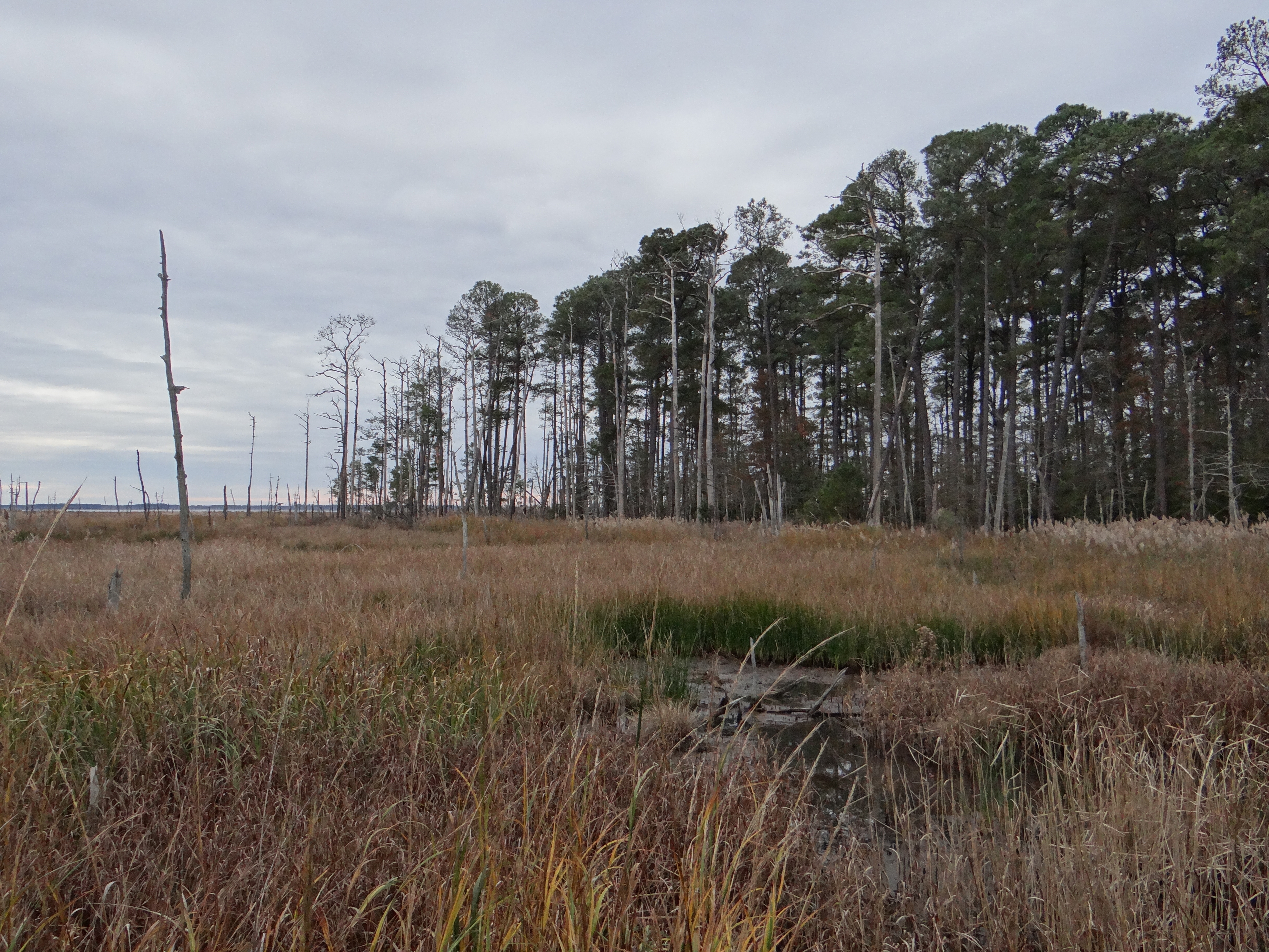 To protect coastal wetlands from ongoing threats, managers must make rapid yet informed decisions on where to direct limited resources and which restoration techniques will be most effective. Yet even when they have access to a wealth of geospatial data—particularly in well-studied systems like the Chesapeake Bay, which contains more salt marsh acreage than any estuary in the country—the data are not aggregated at a scale that helps them make science-based recommendations.
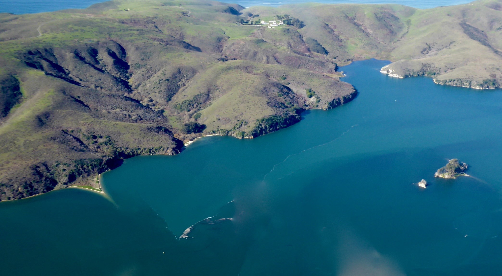 Estuaries with low rates of freshwater inflow are an important, but overlooked, area of estuarine science. Because low-inflow estuaries (LIEs) do not fit well into the common estuarine paradigm—a system with continuous inflow of freshwater and lower salinity than the open sea—they haven’t been as well-studied. However, it’s becoming clear that LIEs are widespread and represent an opportunity to expand our understanding of estuarine processes.