- About
- Affiliates
- Join
- Publications
- Estuaries and Coasts
- CERF's Up! Quarterly Bulletin
- Coastal & Estuarine Science News (CESN)
- CERF-Lit
- Advertising
- Programs & Events
- Inclusive Culture
- Communities
Coastal & Estuarine Science News (CESN)The mission of Coastal & Estuarine Science News (CESN) is to highlight the latest research in the journal Estuaries and Coasts that is relevant to environmental managers. It is a free electronic newsletter delivered to subscribers on a bi-monthly basis. Sign up today! 2024 Issue 1Table of ContentsWhy Aren't New York Marshes Keeping Pace With Sea-Level Rise? Why Aren't New York Marshes Keeping Pace With Sea-Level Rise? Losing ground in the root zone 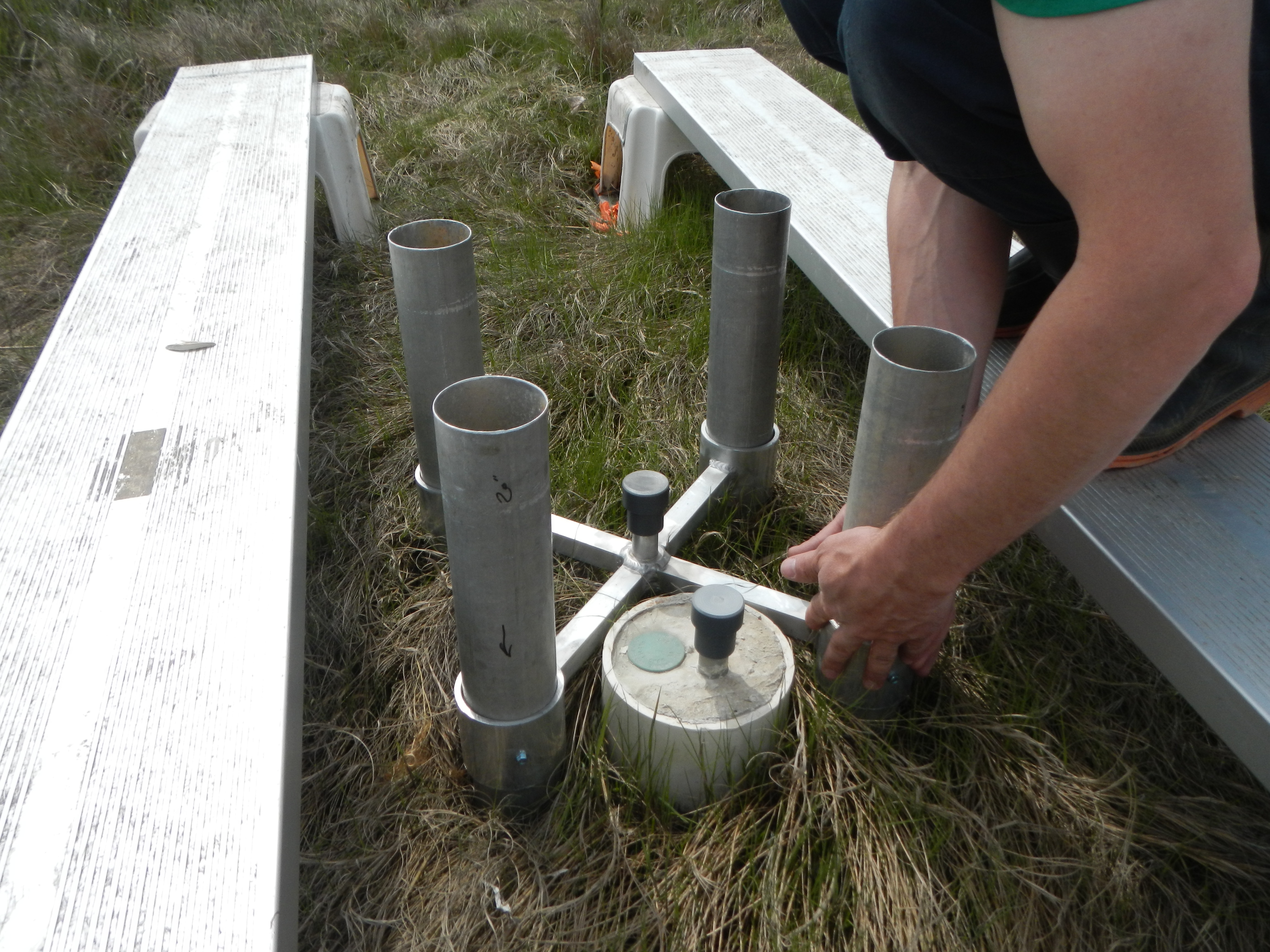 Salt marshes are vulnerable to drowning if they cannot maintain their elevation relative to sea-level rise. And in places without sufficient external sediment supply, the buildup of organic matter in the root zone becomes critical. This is especially important in northeastern marshes, which depend on peat formation to keep pace with sea-level rise. Marsh elevation is affected by processes occurring at the surface (sediment deposition or erosion), in the shallow subsurface (belowground growth or decomposition), and at deeper levels (subsidence or tectonic expansion). To tease these processes apart, researchers installed a network of deep-rod surface elevation tables with associated marker horizons (SET-MHs) and shallow-rod surface elevation tables (RSETs) across seven marshes on Long Island that locally span a range of environmental conditions and positions in the tidal frame. Over the 14-year study period (2008–2022), all but one of the study marshes experienced an elevation deficit relative to sea-level rise. This was not due to surface processes (in fact, all of the study marshes were actively building elevation due to surface accretion), but rather, due to lack of vertical elevation growth within the root zone. It is important to determine the reason for this deficit in order to address it and find ways to enhance belowground growth and the preservation of organic matter. For example, reducing excessive nutrient loading or restoring marsh hydrology may help to optimize conditions for peat formation, which will be key for getting these marshes onto a trajectory that allows them to keep pace with sea-level rise. Source: Maher, N. & A. Starke. 2023. Suboptimal Rootzone Growth Prevents Long Island (NY) Salt Marshes from Keeping Pace with Sea Level Rise. Estuaries and Coasts. DOI: 10.1007/s12237-023-01295-7 Image: Shallow RSET installation nested within deep RSET station. The aluminum pipes are repurposed from the irrigation system used by Nobel Prize winner Barbara McClintock / Nicole Maher, The Nature Conservancy Pilot Living Shoreline Projects Show Promising Results Soft engineering can provide salt marsh habitat Living shorelines use natural materials to stabilize and protect salt marshes, and they provide an alternative to traditional gray infrastructure options such as seawalls and concrete armoring. Since 2016, three pilot projects planned to resemble small natural fringe marshes have been installed in New Hampshire’s Great Bay Estuary; one used coir fiber logs in the seaward sill, while the other two used riprap boulders. From 2019 to 2022, researchers tracked vegetation structure, nekton use, and intertidal soil development in these projects to measure short-term restoration. The utilization of the structural components of the projects (e.g. the constructed sills) by algae and invertebrates was also monitored. Each living shoreline was paired with a nearby reference salt marsh and an adjacent degraded shoreline. The use of living shorelines provided functional salt marsh habitat and helped stabilize the shoreline. After four growing seasons, the visual cover and species richness of communities were similar to reference marshes, as were measures of the resident nekton community. However, the development of hydric soils will take longer than the short time frame of this study. Out of the two methods, riprap supported more algae and invertebrates than coir fiber and was appropriate for more exposed shorelines with natural rock outcrops. Coir, more suitable for protected, sandy shorelines, decomposed over time, limiting its long-term ability to reduce wave energy prior to peat formation. Living shorelines are still fairly new, and in this case, some adjustments were necessary to improve their performance. For example, some areas needed to be replanted after winter ice damage or fenced off to keep out foraging geese; accumulated wrack had to be removed and in some places, jute pillows and sediment were added to reduce erosion. Pilot projects can help stakeholders better refine expectations, and their small-scale nature provides the opportunity to attempt new management techniques without substantial costs. Source: McKown, J.G. et al. 2023. Short‑Term Recovery of Pilot Living Shoreline Projects for Salt Marsh Habitat in New Hampshire. Estuaries and Coasts. DOI: 10.1007/s12237-023-01284-w Using acoustic data to construct patterns in fish distributions
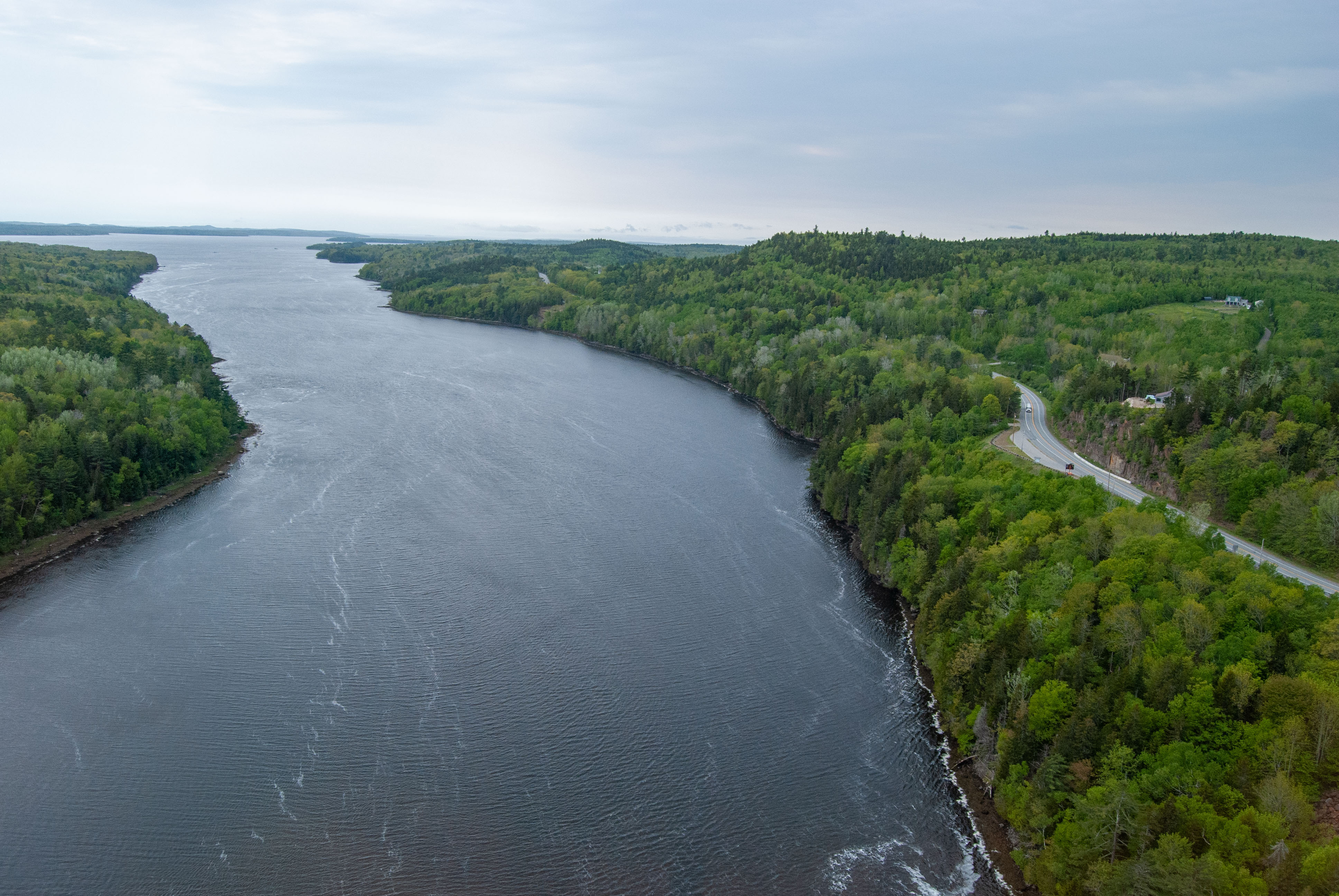
The Penobscot River in Maine has recently been the focus of large restoration projects to increase diadromous fish populations through a combination of dam removal, stock enhancement, and passage improvements (including a fishway and nature-like bypass). To assess river restoration impacts, a team of researchers analyzed acoustic data collected from echosounders throughout the estuary and constructed a time series of the spatiotemporal patterns in fish biomass, size, and density. They compared fish distribution pre- (2012–2014) versus post-restoration (2015–2019). Although there were no differences in fish length between pre- and post-restoration years, median density increased from less than 0.5 fish m−2 to greater than 1 fish m−2, resulting in an approximately threefold increase in fish biomass. These results provide baseline conditions for Penobscot River as restoration proceeds and (optimistically) as diadromous fish populations continue to increase. The approach taken in this paper—which relied on echosounders with only limited trawling (for groundtruthing)—allowed researchers to generate a robust dataset for studying the impacts of restoration with fish metrics. In contrast, trawling alone would be more labor- and time-intensive, potentially impacts the sampled species, and has limited sampling areas. This study is novel in that it provides direct evidence of the positive changes to an estuary ecosystem from river restoration efforts. Source: Stevens, J.R. et al. 2023. Response of Estuarine Fish Biomass to Restoration in the Penobscot River, Maine. Estuaries and Coasts. DOI: 10.1007/s12237-023-01292-w Image: The Penobscot River Estuary, where the largest river in Maine flows into the Atlantic Ocean / Kathlyn Tenga-Gonzalez, Maine Sea Grant Using UAVs to Model the Hydrology of Tidal Wetlands An accurate and cost-effective approach Tidal wetlands have very low elevation, making them vulnerable to even small changes in sea level. Because a difference of a few centimeters can interfere with hydrological connectivity, high-resolution data on marsh topography is crucial for understanding flooding patterns. Researchers in Australia used high-resolution structure-from-motion data derived from an unoccupied aerial vehicle (UAV), which provided detailed information on surface features (e.g. vegetation, roads, and trails), to create a 3-centimeter resolution digital elevation model of an 82-hectare marsh in north Queensland, with an 8-centimeter root mean square elevation error. They used this to develop a 2-D hydrodynamic model of the study site that quantified the duration, depth, and frequency of tidal inundation and hydrological connectivity. Simulations were run to represent 10-day periods in January, June, and August of 2021, and validated with satellite imagery from Sentinel-2 and in-field water-level loggers. Overall, the model performed well in predicting water level and tidal wetland inundation patterns across the study site. However, model errors were higher in densely vegetated areas; in mangrove forests, for example, elevation tended to be overestimated. This high-resolution approach demonstrates how small changes in topography—such as vehicle tracks and differences in water level from a culvert—can result in important variations and modify the total area of the wetland being inundated. Despite some challenges, this is a relatively simple approach that uses freely available software and minimal data inputs to provide fairly good resolution of low-relief coastal wetlands. These models can help with planning restoration and protection projects that consider tidal flooding dynamics. They can also be used to predict impacts of different sea-level rise projections. Source: Vulliet, C. et al. 2023. Assessing Tidal Hydrodynamics in a Tropical Seascape Using Structure–from–Motion Photogrammetry and 2D Flow Modelling. Estuaries and Coasts. DOI: 10.1007/s12237-023-01288-6 |