- About
- Affiliates
- Join
- Publications
- Estuaries and Coasts
- CERF's Up! Quarterly Bulletin
- Coastal & Estuarine Science News (CESN)
- CERF-Lit
- Advertising
- Programs & Events
- Inclusive Culture
- Communities
Coastal & Estuarine Science News (CESN)The mission of Coastal & Estuarine Science News (CESN) is to highlight the latest research in the journal Estuaries and Coasts that is relevant to environmental managers. It is a free electronic newsletter delivered to subscribers on a bi-monthly basis. Sign up today! 2024 Issue 4Table of ContentsModeling Shellfish Nitrogen Removal Modeling Shellfish Nitrogen Removal Harvesting oysters after 2.5 years beats harvest-when-ready.
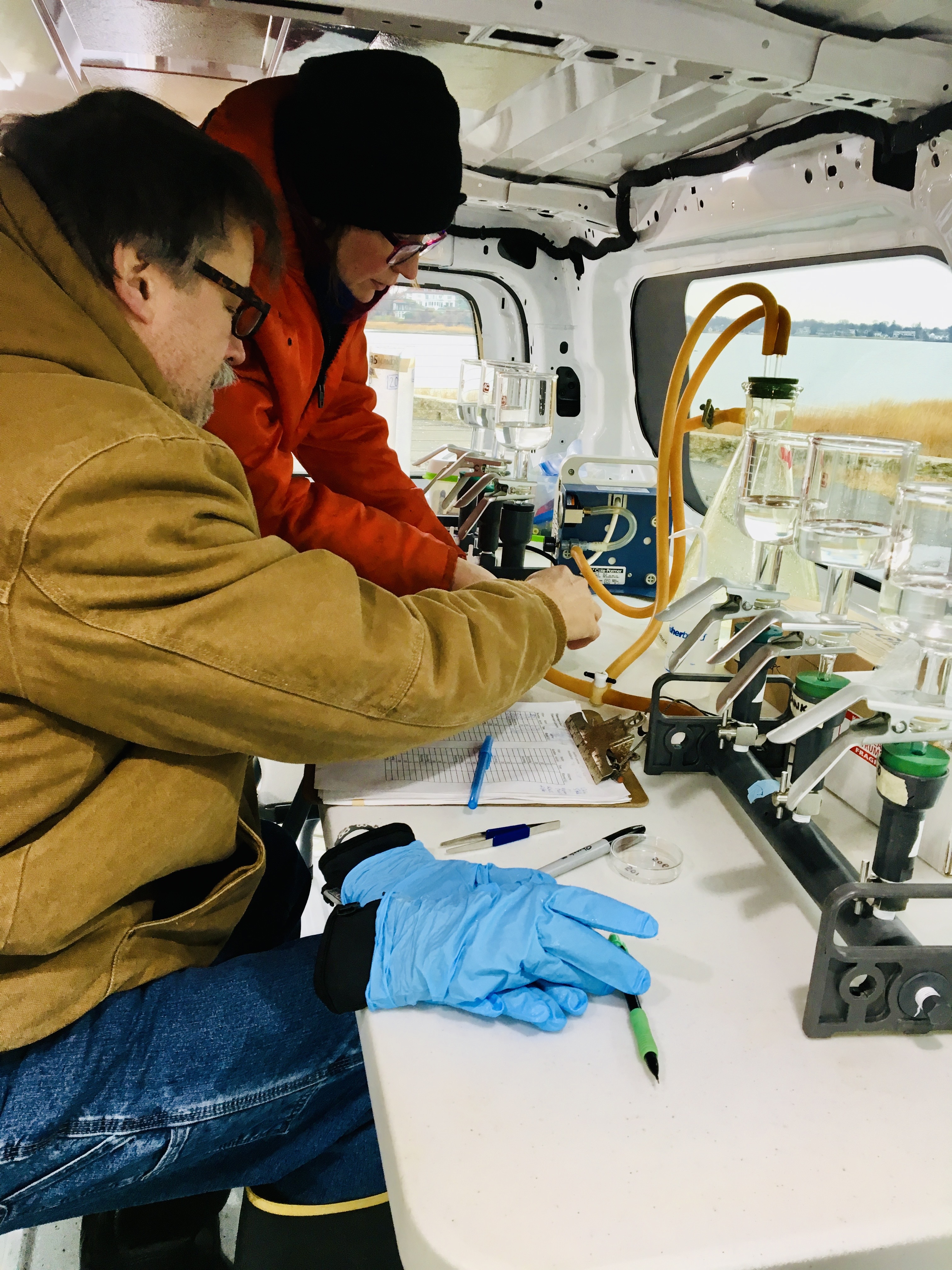
Although reducing nitrogen inputs has helped to improve coastal ecosystems, persistent eutrophic conditions have led managers to seek additional control solutions—including bivalve shellfish aquaculture. These filter feeders incorporate nitrogen into their tissue and shells as they grow, and when they are harvested, these nutrients are removed from the waterbody as well. Researchers partnered with an Eastern oyster (Crassostrea virginica) farm on Connecticut’s Long Island Sound to collect new field and experimental data to improve model estimates of both oyster growth (using the individual-based AquaShell Model) and nitrogen removal (with the widely utilized Farm Aquaculture Resource Management, or FARM, population model). They collected monthly oyster samples and environmental measurements including water quality; they also conducted filter feeding experiments on individual oysters and made respiration measurements in chambers. During the 912-day culture cycle, the AquaShell Model estimated that an Eastern oyster can clear 47.6 m3 of seawater, consume 38 grams of oxygen, and remove over 0.88 grams of nitrogen on average. When different harvest scenarios were compared using the FARM model, they found that harvesting oysters all at once after a 2.5-year grow-out period would remove an estimated 274 kilograms of nitrogen per hectare per year, which was almost twice as much compared with a harvest-when-ready scenario (159 kilograms of nitrogen per hectare per year). Nitrogen removal was greater using the non-harvest-when-ready mode because oysters remained in the water longer and continued to grow. The approach taken in this study expanded the parameterization of the FARM model and improved its ability to predict nitrogen removal benefits and utility as a planning tool for deciding where and how different cultivated species elsewhere could be most effective at reducing nitrogen in the environment. Source: Bayer, S.R. et al. 2024. Refining the Farm Aquaculture Resource Management Model for Shellfish Nitrogen Removal at the Local Scale. Estuaries and Coasts. DOI: 10.1007/s12237-024-01354-7 Image: Researchers filtering samples for FARM model environmental inputs from an oyster farm lease's water in Greenwich, Connecticut / Skylar Bayer Integrating Uncertainty in Wetland Migration Estimates A tool for accurately identifying places where wetlands can migrate.
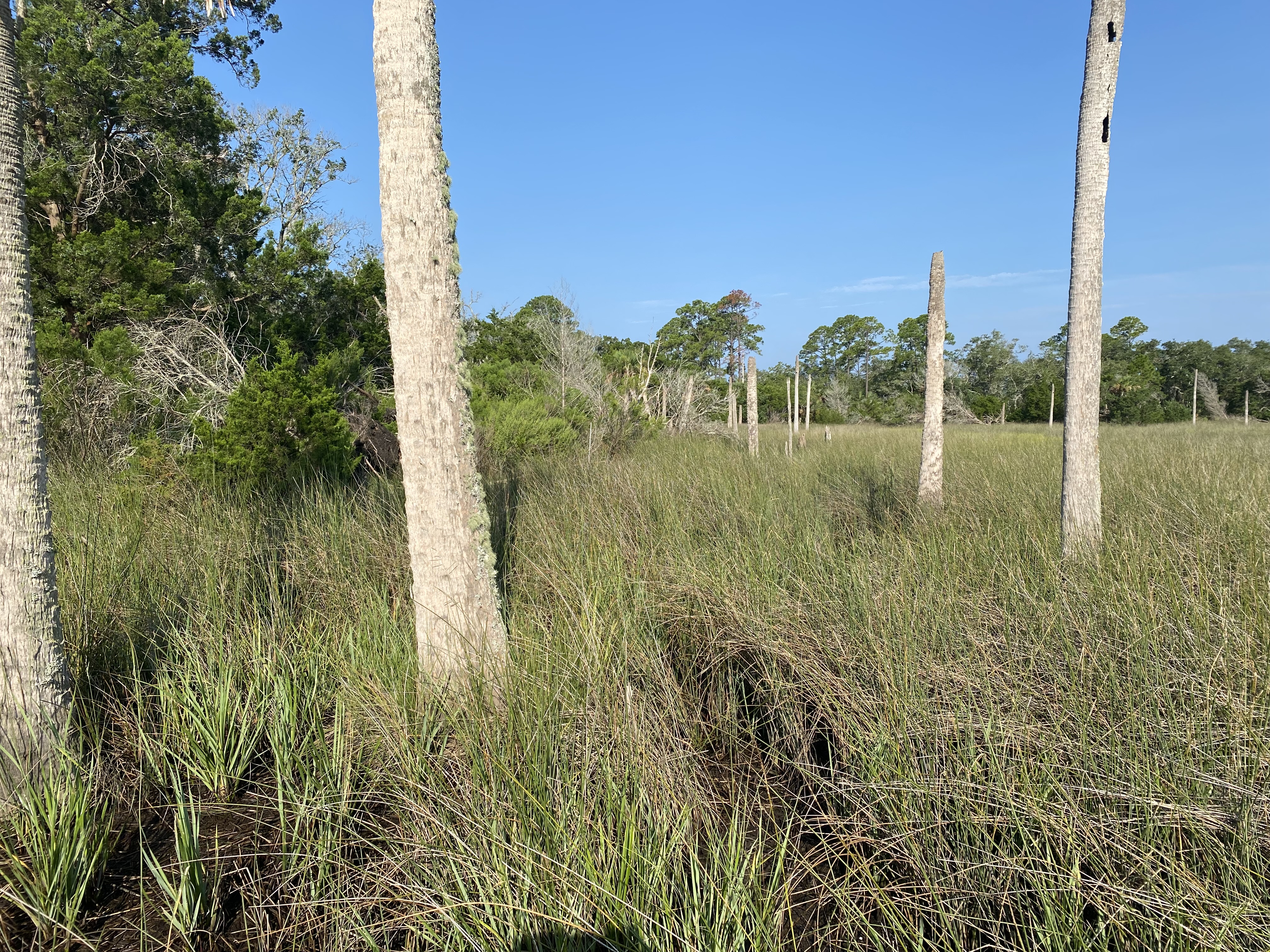
Using Duvall and Nassau counties in northeast Florida as a case study, researchers identified potential wetland migration areas while integrating uncertainty in ground surface elevation, current water levels, and sea–level rise scenarios. Publicly available USGS digital elevation models (DEMs) developed from lidar data collected in 2018 and 2019 were used as the original elevation source data for this study, and these were related to on-the-ground measurements to reduce the DEM error (from -0.159 m to -0.008 m). Then using the reduced error DEM, they focused on the migration of both regularly and irregularly flooded wetlands and identified land cover and land use types vulnerable to future ocean water exposure. Specifically, these assessments were created using Monte Carlo simulations to assess the probability of an area being within regularly or irregularly flooded zones using two sea–level rise scenarios (intermediate low and intermediate high) for 2050 and 2100. They found that overall migration space increased with sea–level rise: In the “intermediate low” scenario, migration space doubled from around 9,000 hectares in 2050 to over 18,600 hectares in 2100, whereas in the “intermediate high” scenario, it increased from 13,700 to 25,200 hectares. Gently sloping areas had more potential for migration than steep slopes. They also identified topographic barriers that will constrain wetland migration using NOAA land cover data. Assuming developed areas would be protected (and marsh migration would therefore not be allowed to occur), they found that Nassau River had more migration potential than St. Johns River due to more development along the latter. This approach can help reduce the uncertainty and overestimation of elevation found with existing DEMs and help enhance screening tools used for coastal land management and planning. These products can provide insights before more complex geospatial or hydrodynamic modeling is conducted and can help guide various management actions, including land acquisition. Source: Enwright, N.M. et al. 2024. Enhancing Assessments of Coastal Wetland Migration Potential with Sea‑level Rise: Accounting for Uncertainty in Elevation Data, Tidal Data, and Future Water Levels. Estuaries and Coasts. DOI: 10.1007/s12237-024-01363-6 Image: Impact of changes to exposure to oceanic water along the forest–marsh transition in the Timucuan Ecological and Historic Preserve in Jacksonville, Florida / Nicholas Enwright The Lasting Benefits of Temporary Sills Mitigating salt intrusion during times of drought.
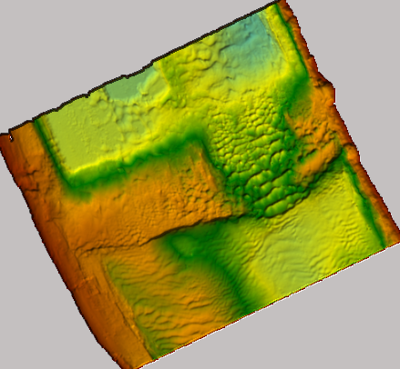
The combination of sea–level rise and drought brought on by climate change is making estuaries increasingly susceptible to upstream saltwater intrusion. One way to protect upstream freshwater resources during periods of low flow is to construct temporary earthen sills. For example, during a recent drought event in the Lower Mississippi River, the advancing salt wedge threatened to contaminate the drinking water of New Orleans. In response, a submerged, broad-crested dam was constructed from local sediments. It remained in place during low-flow conditions to block saline water in the deeper part of the water column from extending landward while still enabling the discharge of freshwater downstream closer to the surface. Researchers wanted to assess the role of estuarine type, circulation, and tidal regime on the ability of temporary sills such as this to effectively mitigate drought-induced saltwater intrusion. According to their modeling experiments, sills would work well in salt-wedge estuaries with stratification typical of river-dominated estuaries. However, their effectiveness would decrease with increases in tidal energy: In tidal-dominated systems, sills would be less effective where they act as a speed bump, reducing the landward momentum of saltwater but not stopping it. The height and location of the sill is also critical to its effectiveness. A sill height that’s half of the water column is the most effective; and if the sill is placed too far upriver, for example, it can exacerbate upriver saltwater intrusion. These height and placement constraints may limit their widespread use. In estuaries with just sufficient depth to accommodate vessel passage, a sill would obstruct vessels and be an obstacle for the port. Whereas a permanent sill would obstruct the flow during non-drought conditions, increasing flood risk, temporary sills should naturally flush away with higher flows—making them a nature-based solution that can work under the right conditions. Source: Hendrickx, G.G. et al. 2024. An Earthen Sill as a Measure to Mitigate Salt Intrusion in Estuaries. Estuaries and Coasts. DOI: 10.1007/s12237-024-01359-2 Image: Bathymetry scan with the sill as used in the Lower Mississippi River / USACE Assessing Vulnerability on the Cameroon Coast Combining traditional methods with machine learning in Africa.
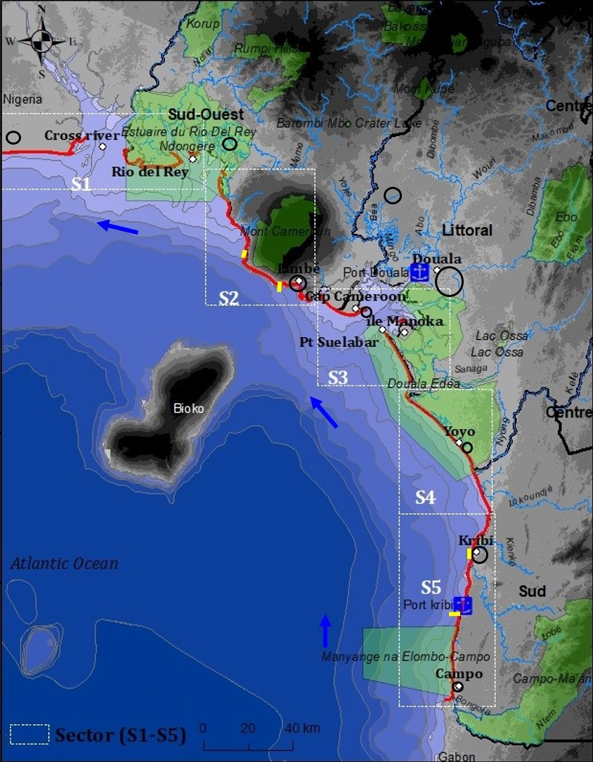
The coast of Cameroon harbors diverse marine ecosystems as well as wetlands vital to local communities. However, the effects of rapid urbanization, natural resource exploitation, and climate change will result in displacement of the human population and reductions in wetland biodiversity. Few studies have been conducted on coastal hazards along the Gulf of Guinea, and to fill this gap, researchers combined traditional assessment methods with machine learning techniques to assess vulnerability of coastal areas to hazards such as erosion, storms, and sea–level rise. Using existing geospatial data and field observations in Bonny Bay, researchers collected geological, physical, and socio-economic parameters (such as elevation, significant wave height, land cover, population density, and road network) and assigned each a vulnerability class ranging from very low to very high. For example, a village, small town, large town, and city were classified as low, moderate, high, and very high, respectively. Then, using those categorized inputs, they calculated an integrated coastal vulnerability index (ICVI) three ways. First, a “simple” method with calculations traditionally used to generate a coastal vulnerability index, and then a multi-criteria analytic hierarchy process (AHP)—a weighted version of the simple method. And finally, six machine learning algorithms trained on (and evaluated against) the AHP calculations of vulnerability. The IVCI calculated by the simple method showed higher variability than the AHP approach, which had a more balanced distribution of vulnerability levels. The AHP approach offers a more nuanced and detailed assessment, but can be prone to subjectivity since it relies on human judgments to establish weights and comparisons between criteria; the simple method, while more accessible and easier to implement, can underestimate complex interactions between factors like geomorphology, slope, coastal erosion, and population density—which could all influence vulnerability. And finally, with the exception of one, the machine learning algorithms performed well (and similarly to each other) at predicting coastal vulnerability. Of these, the artificial neural network worked best. Combining approaches offers a more comprehensive assessment of coastal vulnerability, and comparing them makes it possible to leverage the different benefits of each. Source: Nourdi, N.F. el al. 2024. Integrated Assessment of Coastal Vulnerability in the Bonny Bay: A Combination of Traditional Methods (Simple and AHP) and Machine Learning Approach. Estuaries and Coasts. DOI: 10.1007/s12237-024-01362-7 Image: Bonny Bay / The Authors |