- About
- Affiliates
- Join
- Publications
- Estuaries and Coasts
- CERF's Up! Quarterly Bulletin
- Coastal & Estuarine Science News (CESN)
- CERF-Lit
- Advertising
- Programs & Events
- Inclusive Culture
- Communities
Coastal & Estuarine Science News (CESN)The mission of Coastal & Estuarine Science News (CESN) is to highlight the latest research in the journal Estuaries and Coasts that is relevant to environmental managers. It is a free electronic newsletter delivered to subscribers on a bi-monthly basis. Sign up today! 2024 Issue 6Table of ContentsNo Geese Allowed Fences keep out the geese but allow non-native plants to invade
To examine the effectiveness of these exclosures, researchers studied the composition of aboveground vegetation and surface seed banks in two Vancouver Island estuaries: one with 1-year-old exclosures and a second with 10-year-old exclosures. They compared observations from within the exclosures to those from both undisturbed sites and sites being actively grazed and grubbed. The undisturbed sites in both estuaries and the 10-year old exclosure had the greatest abundance of aboveground vegetation, which was dominated by tall, perennial graminoids such as sedges and rushes. Although the 10-year-old exclosures had greater mean cover and greater proportion of seeds than the undisturbed sites, they were dominated by non-native, invasive species. Grubbed sites in both estuaries and the 1-year-old exclosures had around 190% lower proportion of seeds than undisturbed sites; they both also had 193% and 97% less mean cover of tall, perennial graminoids, respectively. These results suggest that recovery from intense herbivory can take many years and that exclosures alone may not be enough—especially when there’s a high abundance of non-natives to invade the blank slate left behind by intensive grazing and grubbing. The authors recommend restoring a diversity of native species through seeding or transplanting (or both) as soon as possible following removal of grazing disturbance, coupled with the continued use of exclosures. Source: Lane, S.L. et al. 2024. Passive Recovery Risks Non‑native Vegetation Invasion Following Intensive Herbivory by Canada Geese in Two Salish Sea Estuaries. Estuaries and Coasts. DOI: 10.1007/s12237-024-01419-7 Image: Resident geese eating / Gerry Fairbrother and Guardians of Our Salish Estuaries Society A Decision Tool for Designing Living Shorelines Considering future conditions induced by sea-level rise
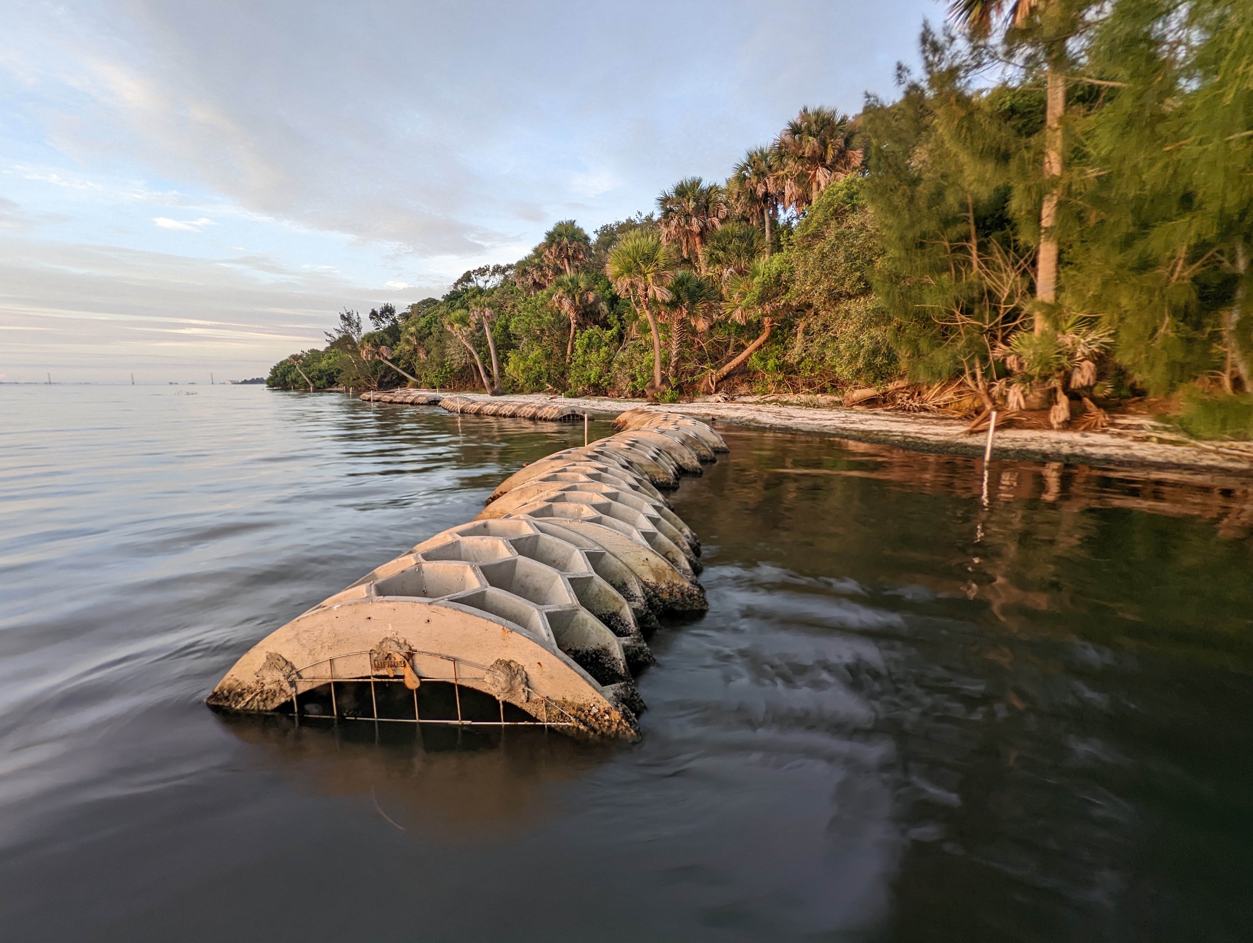
To help coastal practitioners evaluate potential locations in light of climate change, researchers created a web-based geospatial living shoreline decision support tool called Future Shorelines. The tool models submergence, shoreline change, and other future conditions induced by sea-level rise by combining elevation and slope data with NOAA Interagency Sea Level Rise Scenarios. Users can select a parcel on a map and choose a sea-level rise projection scenario, and the tool generates the extent of potential inundation and habitat migration by displaying slope along a transect from the shoreline extending landward. The tool also provides information on private land ownership in parcels adjacent to the selection—which might prohibit landward migration or hamper efforts to monitor and maintain an installation. The tool also allows the user to select locations where intertidal areas suitable for wetland colonization are predicted to expand. Beyond living shoreline design, the tool’s elevation and shoreline profile features can also be used to help design topographic recontouring projects for restoring areas degraded by historical fill or spoil deposition. And lastly, demographic information is provided to include environmental justice considerations in site selection. Although developed for use in the Indian River Lagoon in Florida, Future Shorelines can be readily adapted for application in other locations if the input data are available. Source: Parkinson, R.W. et al. 2024. Future Shorelines: A Living Shoreline Site Selection and Design Decision Support Tool that Incorporates Future Conditions Induced by Sea Level Rise. Estuaries and Coasts. DOI: 10.1007/s12237-024-01425-9 Image: Nature-based Reef Arches wave break installation in the Indian River Lagoon / Marine Resources Council Effects of Living Shorelines on Nekton Can Take Years Results from a before-after-control-impact paired series at multiple sites
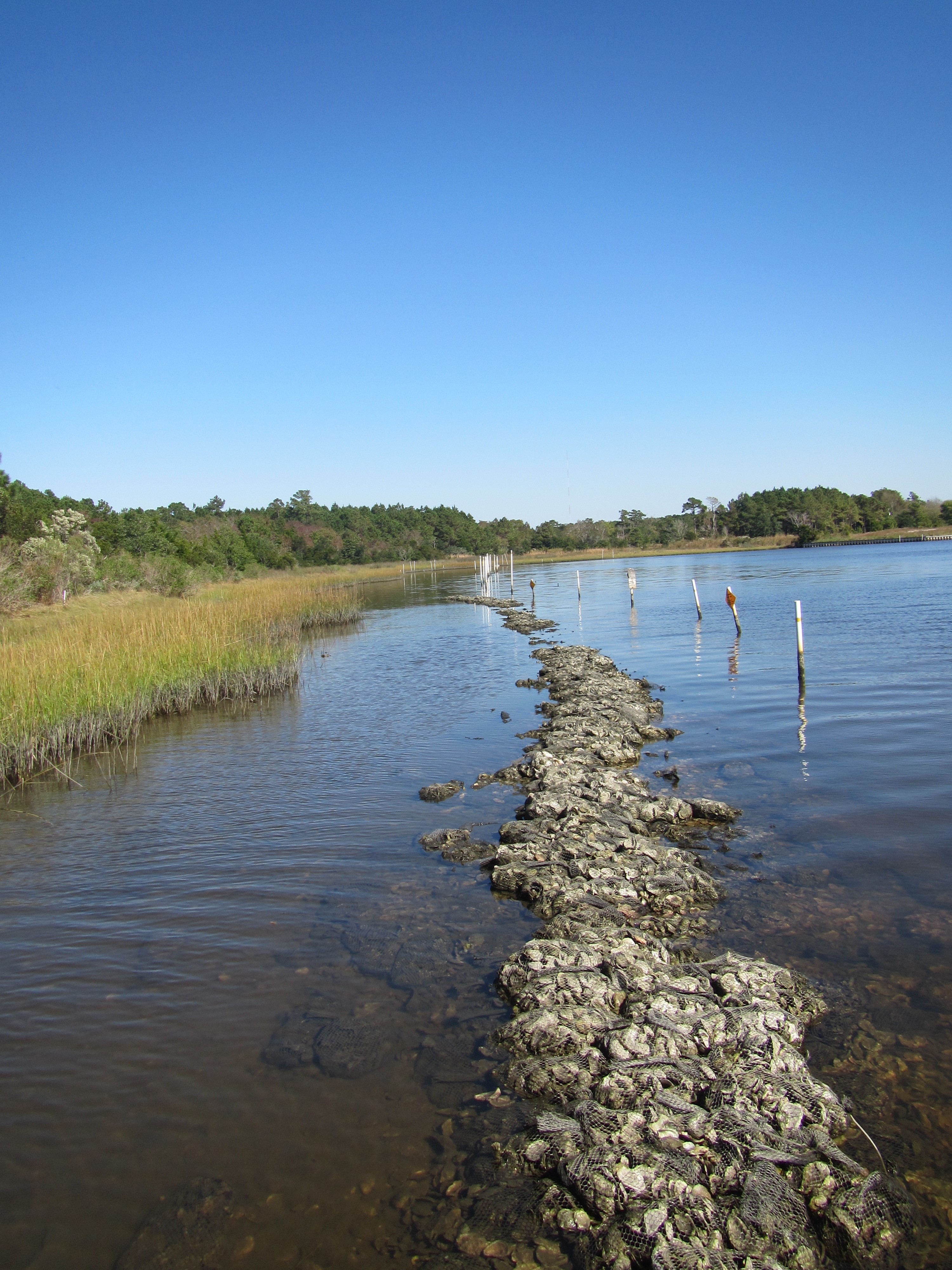
To understand how living shoreline installation impacts nekton communities over time, researchers resampled four locations in coastal North Carolina that were originally sampled before and immediately after construction between 2010 and 2012. Paired sites composed of one natural control shoreline and one living shoreline in close proximity with similar physical characteristics (such as vegetation and wave and tidal exposure) were sampled again in 2016. All living shorelines were built with a low nearshore sill of either granite rocks or bagged oyster shells with marsh plantings landward of the sill. Across all sites and years, the team caught a total of 9,538 nekton. Overall, nekton biomass, abundance, species richness, and community composition were similar between natural and constructed shorelines four to five years post-construction. Living shorelines likely increase food availability for nekton and provide refuge from predators. This may be related to structural stability: Rock sills seemed to maintain their structure and vertical relief over time better than oyster bag sills. In keeping with this, the team also found that granite rock sills enhanced nekton communities. Several response metrics demonstrated a linear increase over time, indicating that advantages for nekton may take time to manifest, rather than being immediately apparent. Post-construction monitoring of living shoreline projects beyond the first few years is rare, and this study (the longest duration of its kind) suggests that even five years might not be long enough to fully understand their impacts, benefits, and unintended consequences. Source: Smith, C.S. et al. 2024. Living Shorelines Equal or Outperform Natural Shorelines as Fish Habitat Over Time: Updated Results from a Long‑Term BACI Study at Multiple Sites. Estuaries and Coasts. DOI: 10.1007/s12237-024-01429-5 Image: Carter Smith Does Dredging Cause Wetland Loss? Yes, But… Over time, wetland loss is dominated by the indirect effects of dredging
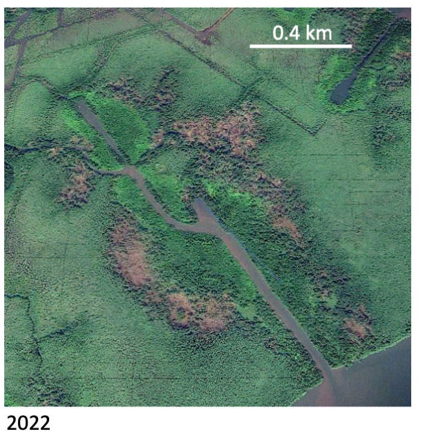
To quantify the indirect effects of dredging, researchers evaluated the relationship between canal density and wetland loss in the Mississippi and Niger river deltas. By compiling decades of information from historic maps, aerial photos, and satellite imagery, they sought to estimate how land loss changed over time and determine potential drivers. Although dredging itself leads directly to land loss in these river deltas, the indirect effects of wetland loss are much larger and play out over longer time periods. Areas with a higher percentage of canals experienced land loss that exceeded loss due to direct dredging alone. Additionally, the ratio of land loss to canal area increased over time: For a given canal density, more wetlands were converted to open water after 40 years compared with after just 10. That observed relationship was not affected by the distance of flood protection levees to the river, nor the status of wells (wet or dry and abandoned)—suggesting that levees and subsidence due to fluid extraction play a minor role in land loss. Instead, the authors argue, the effects were mostly driven by local changes in wetland hydrology: Dredging can lead to either waterlogged soils or longer drying cycles, both of which can lead to plant loss and reductions in vertical accretion. In Louisiana, multiple restoration projects are aimed at redirecting or increasing sediment supply in the Mississippi. One low-cost option is to return the spoil banks back into the canal when a well is no longer in use, thereby allowing the local area to be flooded and restored naturally within a few years. Source: Turner, R.E. & E.I. Ohimain. 2024. Dredged Canals, Wetland Loss, and Legacy. Estuaries and Coasts. DOI: 10.1007/s12237-024-01427-7 Image: Google Earth image of spoil banks between bare areas and the canal in the Niger River delta / R.E. Turner & E.I. Ohimain |